Pack your coffee and cocoa and take a hike into the lap of nature
You can find the hiking map of Haapavesi here

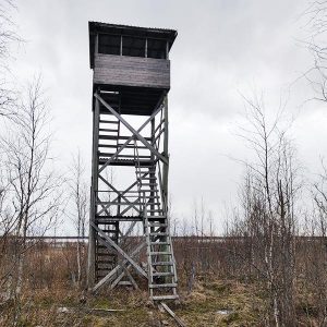
It is one of the most significant bird lakes in Finland. A birdwatcher can spot many rare bird species during spring and autumn migrations.
Distance from the parking lot to the bird tower is about 1.5 km.
It is one of the most significant bird lakes in Finland. A birdwatcher can spot many rare bird species during spring and autumn migrations.
Distance from the parking lot to the bird tower is about 1.5 km.


Birdwatching tower at the shore of Kirkkojärvi in the center.
WGS84 – lat: 64.13114 lon: 25.38144
WGS84 – lat: 64.15338 lon: 25.35594

‘WGS84 – lat: 64.09958 lon: 25.43180

WGS84 – lat: 64.15039 lon: 25.36334
Hyttikallio area has a lit ski/run track of 3.6 km

WGS84 – lat: 64.09678 lon: 25.36639
WGS84 – lat: 64.26970 lon: 25.19206

WGS84 – lat: 63.97839 lon: 25.31777
Turvetie 1272, 86600 Haapavesi
WGS84 – lat: 64.32448 lon: 25.34642
WGS84 – lat: 64.18306 lon: 25.4830

WGS84 – lat: 64.17207 lon: 25.48763

WGS84 – lat: 64.18879 lon: 25.41322
WGS84 – lat: 64.04221 lon: 25.20266

WGS84 – lat: 64.03465 lon: 25.45900
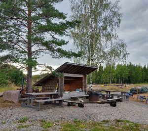
In exchange of the renovation work by the local area association Haapavesi Society, the hut owner allowed to use the pasture hut as a free tourist destination.
WGS84 – lat: 64.10567 lon: 25.72528

WGS84 – lat: 64.28363 lon: 25.41290
WGS84 – lat: 64.14112 lon: 25.15789
Köyryrimpi-Ollikanneva is a large sring big located to the north-east of the Ainali bird lakes. There are also raised bogs in Köyryrimpi. Köyryrimpi-Ollikaanneva is a valuable bird bog.
Köyryrimpi and Ollikkaanneva bog is is one of the last natural examples of string bogs that used to be very typical to Haapavesi. (Kirjastovirma)
aapasoista. (Kirjastovirma)

Turn from Metsoperäntie onto Veneneva forest road. Drive a little over 2 km. On the left side of the road, there is an independent lean-to shelter. About 200 meters ahead, there is a snowmobile trail turning left. By following the snowmobile trail for approximately 700-800 meters, you will reach the Halmenlampi lean-to shelter. Next to it is the beautiful Halmenlampi and a stunning marsh area. It’s worth visiting the marsh on your excursion.


Turn from Metsoperäntie onto Veneneva forest road. Drive a little over 2 km. On the left side of the road, there is an independent lean-to shelter. About 200 meters ahead, there is a snowmobile trail turning left. By following the snowmobile trail for approximately 700-800 meters, you will reach the Halmenlampi lean-to shelter. Next to it is the beautiful Halmenlampi and a stunning marsh area. It’s worth visiting the marsh on your excursion